
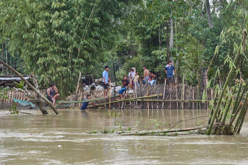
Assam continues to deal with severe flooding, despite marginal improvement. As of Saturday, July 20, 2024, official sources report nearly 200,000 people across 10 districts affected by the deluge. This recurring crisis underscores the urgent need for long-term solutions to mitigate the impact of annual flooding.
While the overall flood situation has improved, two major rivers, including the Brahmaputra, continue to flow above the danger level. Flood-affected districts include Cachar, Dhemaji, Dhubri, Dibrugarh, Goalpara, Golaghat, Kamrup Metropolitan, Karimganj, Nagaon, and Sivasagar. Nagaon is the worst hit, with over 74,000 people affected, followed by Cachar (36,000) and Dhubri (20,000). The total number of people impacted by the floods is 207,000.
Assam flood crisis continues
The human cost of this year’s floods has been staggering. The combined toll from floods, landslides, storms, and lightning strikes has risen to 106, marking a grim milestone in the state’s battle against natural calamities. The floods have not only claimed human lives but have also wreaked havoc on the state’s infrastructure, causing significant damage to embankments, houses, roads, and bridges across various affected districts.
The floods have heavily impacted the state’s wildlife, especially in Kaziranga National Park. 214 animals have died, but 155 were rescued by officials and volunteers.
In response to the improving situation, the Assam Police has eased restrictions on vehicular movement in the Kaziranga National Park. Commercial trucks can now move through the park area during daytime hours (5:00 AM to 6:00 PM) without piloting, albeit at regulated speeds. This decision aims to balance commerce with wildlife protection. The government has set up 61 operational relief camps and distribution centers to cater to the displaced population, providing shelter and support to more than 16,600 affected individuals.
The floods have devastated Assam’s agricultural sector, the backbone of the state’s economy. Over 10,228 hectares of cropland remain submerged, raising concerns about food security and the economic impact on farming communities. The loss of crops and damage to agricultural land will have long-lasting effects on the state’s rural economy.
Assam’s struggle with floods is not recent. The state, with its vast river network dominated by the Brahmaputra and Barak, is prone to natural disasters like floods and erosion. These annual calamities have significantly impacted the state’s development. According to assessments by the Rastriya Barh Ayog (RBA), about 39.58% of Assam’s total land area is flood-prone, alarming when compared to the national average of 10.2%, highlighting the disproportionate impact of floods on Assam.
Assam faced major floods
The state has faced major floods in 1954, 1962, 1972, 1977, 1984, 1988, 1998, 2002, 2004, and 2012, with an average annual loss estimated at around Rs. 200 crores. In severe years, like 2004, the losses soared to Rs. 771 crores. Adding to the flood woes is river bank erosion. Since 1950, over 4.27 lakh hectares of land have been eroded by the Brahmaputra and its tributaries, accounting for 7.40% of the state’s area. The annual average land loss to erosion is nearly 8,000 hectares, with the Brahmaputra’s width increasing up to 15 kilometers in some places due to bank erosion.
Experts warn that floods in Assam may worsen due to climate change. Rising temperatures lead to increased glacial melt in the Himalayas, potentially causing more severe flooding in the Brahmaputra basin. This trend poses challenges for flood management and mitigation strategies.
As Assam grapples with this recurring crisis, there’s a growing call for comprehensive, long-term solutions. Experts advocate for improving flood forecasting and early warning systems, enhancing river embankments and flood control infrastructure, promoting sustainable land use practices and afforestation, developing climate-resilient agricultural techniques, implementing stricter regulations on construction in flood-prone areas, and increasing community preparedness through education and training programs.
The state and central governments are under pressure to allocate more resources for flood management and implement innovative solutions to break the cycle of annual devastation. As the waters recede and reconstruction begins, the people of Assam demonstrate their resilience. However, without significant interventions and long-term planning, the state remains vulnerable to its rivers.
ALSO READ: PM 2.5 pollution spikes in summer, not just winter: Study
The annual floods in Assam underline the urgent need to address climate change and its impacts on vulnerable regions. The coming months will be crucial as the state recovers from this disaster and prepares for future challenges. The nation’s eyes remain on Assam, hoping for a future where the mighty rivers become a source of prosperity rather than devastation.
Brahmaputra river’s erosion
The flood problem in Assam is worsened by flash floods from neighboring states like Arunachal Pradesh and Meghalaya. In 2004 and 2014, the south bank tributaries of the Brahmaputra in lower Assam experienced high-magnitude flash floods due to cloud bursts in Meghalaya. In August 2011, cloud bursts in Arunachal Pradesh caused the Gainadi and Jiadhal rivers to experience very high-magnitude flash floods, leading to large-scale devastation and loss of human lives.
The Brahmaputra river’s erosion causing a dramatic widening, reaching up to 15 kilometers, presents an alarming picture. This not only leads to land loss but also changes the river’s dynamics, potentially worsening flood risks in certain areas.
Despite the challenges, there are opportunities for innovative solutions. Some experts propose a comprehensive river basin management plan for the entire Brahmaputra river system, including its tributaries, involving international cooperation. The river originates in Tibet and flows through India and Bangladesh. Improved water sharing agreements and joint flood management strategies could mitigate the impact of floods.